GNSS in Agricultural Market Revenue, Trends, and Strategic Insights by 2035
GNSS in Agricultural Market Size
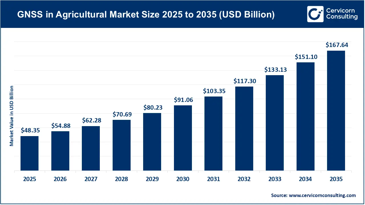
The global GNSS in agricultural market was valued at USD 48.35 billion in 2025 and is projected to reach approximately USD 167.64 billion by 2035, expanding at a 13.24% CAGR from 2026 to 2035.
What Is GNSS in Agricultural Market?
The Global Navigation Satellite System (GNSS) in agricultural market comprises positioning technologies, receivers, antennas, correction services, software, and integration solutions used to improve the accuracy and automation of farming operations.
GNSS is a broader term than GPS. GPS is operated by the United States, while GNSS can incorporate multiple satellite constellations, including GPS, Galileo, GLONASS, and BeiDou. In agriculture, GNSS receivers installed on tractors and other machinery determine the machine’s position and direction.
When connected with correction technologies such as Real-Time Kinematic (RTK), Satellite-Based Augmentation Systems (SBAS), or Precise Point Positioning (PPP), GNSS can provide positioning accuracy ranging from sub-meter levels to centimeters.
This positioning information supports:
- Automatic tractor steering
- Precision planting and seeding
- Yield mapping
- Variable-rate fertilizer application
- Precision spraying
- Soil sampling
- Field boundary mapping
- Controlled traffic farming
- Irrigation management
- Machinery guidance
- Fleet and asset tracking
- Autonomous agricultural machinery
The U.S. government’s GPS.gov explains that precision agriculture uses geospatial information to enable site-specific treatment of fields, helping farmers improve production while reducing unnecessary input use and environmental impacts.
Get a Free Sample: https://www.cervicornconsulting.com/sample/2758
Why Is GNSS Important for Agriculture?
GNSS is becoming a foundational technology for digital and precision agriculture because farming decisions increasingly depend on knowing where an activity is taking place.
Traditional farming often applies seeds, fertilizer, pesticides, and water relatively uniformly across a field. However, fields contain significant variation in soil quality, moisture, nutrient availability, elevation, weed pressure, and crop health.
GNSS allows farmers to associate this variability with precise geographic coordinates. A tractor can therefore follow predefined paths, return to the same locations, apply inputs according to digital prescriptions, and generate location-based operational records.
The benefits include:
Improved Field Efficiency
Automatic guidance reduces unnecessary overlaps and skips. John Deere’s AutoTrac, for example, provides hands-free guidance and is designed to reduce overlaps while saving time and fuel. Its StarFire receiver provides satellite-based guidance for accurate parallel rows.
Reduced Input Consumption
GNSS-supported variable-rate application allows farmers to apply inputs according to field requirements rather than treating the entire field identically.
Better Productivity
Accurate planting and harvesting can improve row consistency, reduce crop damage, and increase the area that can be managed within available operating windows.
Lower Labor Dependence
Automatic steering reduces the amount of manual intervention required from operators and supports increasingly autonomous equipment.
Improved Sustainability
Precision application can reduce excessive use of fertilizers, herbicides, pesticides, fuel, and water.
Foundation for Autonomy
GNSS is one of several technologies required for autonomous agricultural machinery. High-accuracy positioning can be combined with cameras, radar, LiDAR, inertial sensors, machine vision, AI, and digital maps.
Major Companies in the GNSS in Agricultural Market
| Company | Specialization | Key Focus Areas | Notable Features | 2025 Revenue* | Market Position / Global Presence |
|---|---|---|---|---|---|
| John Deere | Agricultural machinery and integrated precision agriculture | Auto guidance, machine automation, precision planting, spraying, farm data | AutoTrac, StarFire receivers, Operations Center, See & Spray | USD 45.68B total company revenue | Strong North America, Europe, Latin America and Asia-Pacific presence |
| Trimble | GNSS positioning, correction services and precision agriculture | RTK/PPP, guidance, autonomy, mixed-fleet agriculture | Trimble RTX, ProPoint, NAV controllers, PTx Trimble | USD 3.59B total company revenue | Global positioning and precision-agriculture footprint |
| AG Leader | Aftermarket precision-agriculture electronics and software | Guidance, application control, planting, yield monitoring | Retrofit solutions and machine compatibility | Private; revenue not publicly disclosed | Strong North American aftermarket presence with international distribution |
| Topcon Agriculture | GNSS, machine control and farm management | Automated guidance, precision planting, yield monitoring, correction services | Topcon Agriculture Platform, GNSS correction services | JPY 222.59B Topcon FY2025 total company sales | Global presence across North America, Europe, Japan and Asia-Pacific |
| Hexagon Agriculture | Positioning, autonomy, geospatial technology and agricultural automation | GNSS, sensor fusion, autonomy, mapping, machine control | High-precision positioning and broader Hexagon digital ecosystem | ~EUR 5.4B Hexagon group net sales | Global operations spanning Europe, North America, Asia-Pacific and other markets |
John Deere
John Deere has developed one of the most vertically integrated precision-agriculture ecosystems. Its portfolio includes tractors, combines, sprayers, planters, guidance systems, satellite receivers, farm-management software and automated application technologies.
John Deere reported USD 45.684 billion in worldwide net sales and revenues for fiscal 2025. Its Production & Precision Agriculture segment generated USD 4.740 billion in sales during the fourth quarter of fiscal 2025 alone.
AutoTrac is particularly important to the company’s GNSS strategy, while StarFire receivers provide satellite-based positioning. Deere is also combining positioning with machine vision and AI. Its See & Spray technology was used across more than five million acres during the 2025 growing season, with Deere reporting nearly 50% average reduction in non-residual herbicide use among customers using the technology.
Trimble
Trimble is one of the best-known companies in high-accuracy positioning and agricultural GNSS.
Trimble generated USD 3.587 billion in 2025 revenue, while its Field Systems segment generated USD 1.54 billion.
Trimble’s agricultural positioning portfolio includes RTX correction services and advanced GNSS technologies. CenterPoint RTX can deliver accuracy of approximately 2.5 centimeters for supported applications.
Trimble and AGCO created PTx Trimble, a joint venture designed to support mixed-fleet precision agriculture and autonomy. The partnership is particularly important because it expands precision technology beyond a single agricultural equipment ecosystem.
AG Leader
Ag Leader Technology specializes in aftermarket precision-agriculture solutions.
Its products are particularly relevant for farmers operating mixed or older machinery because retrofit technology allows precision capabilities to be added without replacing entire fleets.
AG Leader focuses on guidance, planting, application control, yield monitoring, data management and machine integration.
As a private company, AG Leader does not publicly report revenue in the same manner as listed companies such as Deere or Trimble. Consequently, assigning a precise 2025 revenue or market-share percentage would not be reliable.
Topcon Agriculture
Topcon combines GNSS positioning, machine control, sensors, software and correction services.
Its Topcon Agriculture Platform connects operational information across farming workflows, while its correction-service portfolio ranges from local RTK base stations to larger network-based correction services.
Topcon Corporation reported JPY 222.588 billion in annual sales for FY2025. Agriculture is one of its three major strategic business areas alongside healthcare and infrastructure.
Hexagon Agriculture
Hexagon AB participates in agricultural positioning through its broader geospatial, autonomy, sensor-fusion and digital technology ecosystem.
Hexagon reported approximately EUR 5.4 billion in annual net sales and approximately 24,500 employees across 50 countries.
Its competitive advantage is the combination of high-accuracy positioning with sensors, mapping, autonomy, software and industrial digitalization technologies.
Leading Trends and Their Impact
1. Multi-Constellation GNSS Is Becoming Standard
Modern agricultural receivers increasingly work with multiple satellite constellations. Combining GPS, Galileo, BeiDou and GLONASS improves satellite availability and positioning resilience.
This is particularly valuable in environments where trees, terrain, buildings or atmospheric conditions can interfere with satellite signals.
2. RTK and PPP Are Raising Accuracy Expectations
Farmers increasingly require centimeter-level positioning for high-value operations such as planting, strip tillage, spraying and controlled traffic.
RTK uses correction information from reference stations, while PPP-based systems such as Trimble RTX provide high-accuracy positioning through satellite or internet delivery.
3. GNSS Is Moving From Navigation to Autonomy
GNSS is no longer simply about showing a tractor’s location on a display.
It increasingly serves as the positioning layer for autonomous operations. GNSS can be combined with machine vision, inertial measurement units, radar, LiDAR and AI to enable equipment to understand both its location and surroundings.
4. GNSS Is Becoming Integrated With AI
AI can analyze crop, soil and machine information while GNSS provides the geographic reference.
For example, an AI system can identify a weed, while GNSS and machine-control systems determine where the equipment is located and enable precise application.
John Deere’s See & Spray demonstrates this convergence of machine vision, machine learning, precision application and agricultural machinery.
5. Retrofit Precision Agriculture Is Expanding
Not every farmer can afford to replace existing tractors and implements.
Aftermarket systems from companies such as AG Leader and PTx Trimble can add guidance, application control and other capabilities to existing equipment. This creates a significant opportunity in emerging markets and among mixed-fleet operators.
6. Software and Subscription Services Are Growing
The market is shifting from one-time hardware purchases toward recurring services involving correction signals, cloud connectivity, farm-management software, analytics and data storage.
Trimble reported that software, services and recurring revenue represented 79% of total company revenue in 2025, illustrating the broader industry shift toward recurring technology models.
Successful Examples of GNSS in Agriculture Around the World
United States: Precision Guidance and Targeted Application
The United States remains one of the most mature markets for agricultural GNSS.
Large-scale corn, soybean, wheat and cotton farms use GNSS guidance for planting, spraying, harvesting, soil sampling and field mapping.
John Deere’s AutoTrac technology demonstrates how satellite-based positioning can reduce overlaps and operator fatigue.
The integration of GNSS with machine vision is also expanding. In 2025, Deere reported that See & Spray was used over five million acres and helped customers reduce non-residual herbicide use substantially.
Europe: Galileo and EGNOS-Supported Precision Farming
Europe benefits from its own Galileo satellite navigation system and EGNOS augmentation infrastructure.
GNSS technology supports guidance, field mapping, variable-rate application and machinery automation. The European Union’s broader agricultural policy is also placing increasing emphasis on sustainability, environmental performance and efficient resource use.
The proposed post-2027 Common Agricultural Policy is designed to address climate, environmental and socioeconomic challenges in agriculture, strengthening the policy environment for technologies capable of improving resource efficiency.
Brazil: Large-Scale Precision Agriculture
Brazil represents an important growth market because of its extensive soybean, corn, sugarcane and other commercial farming operations.
Large farms can justify investment in RTK guidance, precision planting, variable-rate application and machine monitoring because small improvements in efficiency can produce substantial financial benefits across thousands of hectares.
The availability of retrofit systems is also particularly valuable for Brazil’s mixed machinery base.
India: GNSS, NavIC and Digital Agriculture
India represents a major long-term opportunity because of its large agricultural workforce, fragmented landholdings, increasing mechanization and growing digital-agriculture ecosystem.
ISRO has identified precision agriculture applications for GNSS-based technologies including farm planning, field mapping, soil sampling, seed sowing, fertilizer application and crop assessment. ISRO has also highlighted the potential of NavIC for precision-agriculture applications.
The Indian government has also emphasized precision agriculture using GPS, sensors and drones to collect localized information about soil, moisture and crop health.
Australia: Broad-Acre Precision Agriculture
Australia’s large farms and challenging operating environments make precision positioning particularly useful.
GNSS is applied to autoguidance, controlled traffic farming, seeding, spraying and field mapping. High-accuracy positioning can reduce unnecessary machinery passes and help operators maintain consistent wheel tracks over multiple seasons.
Global Regional Analysis Including Government Initiatives and Policies
North America
North America is currently the leading regional market for agricultural GNSS. Cervicorn Consulting estimates the North American market at approximately USD 18.02 billion in 2024, projected to reach around USD 63.92 billion by 2034.
The region benefits from:
- Large commercial farms
- High agricultural mechanization
- Strong OEM ecosystems
- Advanced dealer networks
- High adoption of autonomous machinery
- Mature RTK infrastructure
- Strong precision-agriculture R&D
In the United States, GPS availability provides a critical infrastructure layer for precision agriculture. USDA research also recognizes GNSS/GPS as an enabling technology for responding to within-field variability and improving resource management.
Government-funded agricultural research, conservation programs and digital-agriculture initiatives continue to support adoption.
Europe
Europe is a major market because of advanced agricultural machinery, strong precision-farming adoption and the availability of Galileo and EGNOS.
GNSS adoption aligns with European priorities around reducing agricultural environmental impacts, improving resource efficiency and supporting data-driven farming.
The Common Agricultural Policy remains an important policy mechanism because its environmental and climate objectives encourage farmers to adopt technologies that improve input efficiency and documentation.
The EU’s post-2027 CAP proposal emphasizes climate, environmental and socioeconomic challenges facing agriculture, creating favorable conditions for technologies supporting sustainable farm management.
Asia-Pacific
Asia-Pacific is expected to be the fastest-growing regional market through the forecast period.
Key markets include:
- China
- India
- Japan
- Australia
- South Korea
The region combines sophisticated agricultural technology markets such as Japan and Australia with rapidly modernizing agricultural economies such as India and China.
In India, the government’s technology-driven agriculture programs increasingly incorporate satellite data, GIS, drones, AI, IoT and remote sensing.
India’s ICAR Network Program on Precision Agriculture (ICAR-NePPA) brings together 16 ICAR research institutes to develop precision-agriculture technologies involving sensors, remote sensing, AI and ICT.
India is also using space technology for crop forecasting, drought monitoring and crop insurance applications through programs including FASAL and related initiatives.
These policies can indirectly expand the GNSS ecosystem because geospatial positioning is an important component of precision agriculture.
Latin America
Latin America is a significant growth opportunity because Brazil, Argentina and other countries have extensive commercial agricultural operations.
The region’s major crops—including soybean, corn, sugarcane and wheat—are well suited to GNSS-supported mechanization.
Adoption is being supported by:
- Increasing farm mechanization
- Large-scale agricultural operations
- Demand for input optimization
- Precision planting
- Variable-rate fertilizer application
- Autonomous machinery
- Expansion of aftermarket precision systems
Brazil is particularly important because its large commercial farms can generate strong returns from centimeter-level positioning.
Middle East and Africa
The Middle East and Africa currently represent a smaller portion of the global GNSS agriculture market but provide significant long-term opportunities.
In the Middle East, water scarcity is a major driver for precision irrigation, field mapping and resource optimization.
In Africa, GNSS adoption is linked to agricultural mechanization, land mapping, drone applications and the development of digital farming platforms. However, adoption can be constrained by equipment costs, connectivity limitations, fragmented farm structures and limited access to technical expertise.
Government-backed agricultural modernization and digitalization programs could therefore play a major role in accelerating adoption.
Government Initiatives and Policies Shaping the GNSS Agriculture Market
Government policy is becoming increasingly important because precision agriculture requires more than hardware. It depends on satellite infrastructure, correction services, rural connectivity, agricultural research, equipment standards and farmer education.
United States
The U.S. benefits from an established GPS infrastructure and extensive federal agricultural research. Government research organizations are actively studying precision agriculture and GNSS-enabled tractor guidance for resource management.
European Union
The EU’s Galileo and EGNOS infrastructure provides an important technological foundation for agricultural positioning. Meanwhile, CAP environmental objectives encourage more efficient and measurable agricultural practices.
India
India is developing a particularly broad ecosystem combining NavIC, remote sensing, satellites, GIS, drones, AI and precision agriculture. Government initiatives include FASAL, ICAR-NePPA, agricultural mechanization programs and space-based crop monitoring.
The government is also promoting agricultural mechanization through the Sub-Mission on Agricultural Mechanization (SMAM) under the broader RKVY framework.
China
China’s agricultural modernization policies increasingly emphasize smart agriculture, agricultural machinery automation, digital technologies and satellite-enabled applications. The country’s BeiDou navigation system provides an important domestic positioning infrastructure for precision agriculture.
Japan
Japan’s aging agricultural workforce is creating strong incentives for agricultural automation. GNSS guidance, autonomous machinery and robotic agricultural systems can help address labor shortages while improving operational precision.
Australia
Australian agriculture has historically been an important adopter of GPS-guided machinery, particularly for large-scale broad-acre farming. Government-backed agricultural innovation and digital farming programs support the broader ecosystem around precision agriculture.
Future Market Direction
The next stage of GNSS adoption in agriculture will increasingly involve GNSS + RTK/PPP + AI + computer vision + IoT + autonomous machinery + cloud farm management rather than standalone satellite navigation.
The commercial opportunity is therefore expanding from GNSS receivers into correction services, guidance controllers, farm-management software, machine autonomy, precision application and data analytics.
For equipment manufacturers, GNSS is becoming a core component of connected machinery ecosystems. For technology companies, it creates opportunities in positioning services, sensors, cloud software and autonomous systems. For farmers, the value proposition is increasingly centered on achieving more precise operations while using less labor, fuel, fertilizer, chemicals and water.
To Get Detailed Overview, Contact Us: https://www.cervicornconsulting.com/contact-us
Read Report: Direct Air Capture Market Revenue, Trends, and Strategic Insights by 2035